Category: Water Activities
English Peak – Marble Mountain Wilderness
- Recommended Route: North Fork Trail from Mulebridge Campground, up the North Fork of the Salmon River.
- Trail is recommended for mid to late summer due to high flows at creek crossings.
- The Garden Gulch and Little North Fork Trails are not recommended.
- Season: June – October
- Moderate to Difficult Trail
- Camping: Idlewild or Mulebridge Campgrounds on North Fork Salmon River
From the Mulebridge Trailhead going up the North Fork Salmon River:
- 13 miles to Hancock Lake
- @ 6 miles in, Right Hand Fork trail
- @ 8.5 miles in, Lake of the Island Trail
- 2 miles OW to Lake of the Island, river crossing, 4,200 feet elevation
- Lake of The Island: 13 acres, 25 feet deep, 5,600 feet elevation, brook and rainbow trout
- @ 10.5 miles, Abbott Lake Trail, 2 river crossings past Lake of the Island Trail
- 1 mile OW climb to lake, river crossing, 4,800 feet elevation
- Abbott Lake: 8 acres, 20 feet deep, 5,700 feet elevation, brook trout
- @ 10.5 miles Big Meadows/Big Gulch Trail to Wild Lake, Lake Ethel, Lake Katherine, Horse Range Lake, Wooley Creek
- @ 13.5 miles – Horse Range Lake (+3 steep miles from Abbott Cabin)
- @ 14.5 miles – Wild Lake (+4 steep miles)
- Exiting Wooley Creek Trail #5832 = 19 miles from junction with Big Meadows Trail from Wild Lake, to the Wooley Creek Trailhead
- Exiting Marble Rim
- Big Elk Lake is 7.3 miles from Lover’s Camp Trailhead
- Exiting Garden Gulch or Little North Fork Trail – not recommended
Duck Lakes – Russian Wilderness
- 4 miles to Big Duck Lake, 0.5 miles further to Little Duck Lake
- 2+ Day Trip
Details:
- Best season = June to October
- Moderately strenuous hike
- Great views to Mount Shasta, Salmon Mountains and Scott Valley
- Duck Lake Special Interest Area/Botanical Area
- Known as the Miracle Mile, 17 conifer species are present in the drainage
- Relic species: Foxtail pine, Englemann spruce, subalpine and Pacific silver fir
- Approximately 4 hour drive from Eureka, CA on Highway 299 to 3 near Callahan:
- From Highway 3 between Callahan and Etna, CA
- Turn west on French Creek Road for 6.7 miles
- Right on 40N22 for 1 mile
- Right on 41N14 for 1.3 miles to parking area
- Hiking to Duck Lakes from Duck Lake Trailhead @ 4800 feet elevation:
- 4 mile moderate hike from Duck Lake Trailhead to Big Duck Lake
- Big Duck Lake = 26 acres @ 27 feet deep @ 6400 feet elevation
- Eastern brook trout and rainbow trout
- Largest lake in the Russian Wilderness
- 0.5 mile difficult hike with 700 foot elevation gain to Little Duck LakeLittle Duck Lake = 5 acres @ 18 feet deep @ 6700 feet elevation
- Eastern brook trout
- 4 mile moderate hike from Duck Lake Trailhead to Big Duck Lake
- Hiking to Horseshoe Lake:
- 4 mile moderate hike from Duck Lake Trailhead to Horseshoe Lake
- 1.5 mile moderate hike from Duck/Eaton Lakes Trail intersection
- Horseshoe Lake = 6.1 acres @ 21 feet deep @ 6400 feet elevation
- Eastern brook trout and rainbow trout
- Hiking to Lipstick Lake:
- 4 mile difficult hike from Duck Lake Trailhead to Horseshoe Lake
- 3 mile moderate hike from Music Creek Trailhead to Horseshoe Lake
- Horseshoe Lake = 1.25 acres @ 9 feet deep @ 6350 feet elevation
- Eastern brook trout
- Hiking to Eaton Lakes:
- 4.5 mile difficult hike from Duck Lake Trailhead to Eaton Lake
- Approximately 1 mile difficult hike from Duck/Eaton Lakes Trail intersection
- Eaton Lake = 11 acres @ 27 feet deep @ 6600 feet elevation
- Trail is steep and hard to follow, not recommended for stock
- Private property
- Rainbow trout
Links:
- Jan’s Jaunts
- Duck Lakes YouTube Video
- Eaton Lake YouTube video
- Backpacking in Jefferson – Duck/Eaton Lakes article
- Driving Directions – About 4 hours from Eureka, CA via Highway 299 to 3
- Alternative Scenic Route: Salmon River Road
Lost Coast Trail
- Lost Coast
- BLM Lost Coast Trail
- Lost Coast National Recreation Trail
- lostcoasttrails.wordpress.com
- Sinkyone Wilderness
NORTHERN LOST COAST TRAIL
- 24.8 miles along the Pacific Ocean north of Shelter Cove
- Mattole Beach to Black Sand Beach in Shelter Cover
- 3-4 days each way
- Usually hiked north to south for wind reasons
SOUTHERN LOST COAST TRAIL
- 22.1 miles along the Pacific Ocean south of Shelter Cove
- Needle Rock Beach to Usal Beach
- 3-4 days each way
- Usually hiked north to south for wind reasons

Shasta-Trinity National Forest
Lost Coast
The Lost Coast is a rugged coastal wilderness that feels like an escape to another world. As the longest undeveloped coastal region in the contiguous US, you can hike along the ocean for days.
- BLM King Range Conservation Area
- 68,000 acres
- King Range Wilderness
- 42,694 acres
- King Range Trail Map
- King Range Road Map
- Lost Coast Trails Blog
- Lost Coast Scenic Drive
- Punta Gorda Lighthouse
- Lost Coast Headlands
- Paradise Royale Mountain Biking Trail
- Surf the Lost Coast – National Geographic

Klamath National Forest
Red Buttes Wilderness
Yolla Bolly – Middle Eel Wilderness
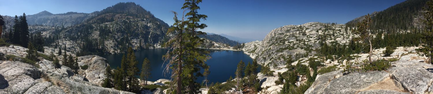
Russian Wilderness
Nor-Cal Adventures Blog Pages:
- Russian Wilderness Lakes
- Russian Wilderness Map
- Salmon River
- Klamath National Forest
- Pacific Crest Trail
Helpful links to other pages:
Hiking Trails:
- Big Blue Lake Loop = 8.5 miles
- Paynes Lake
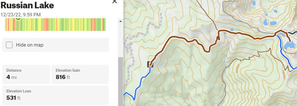
- Russian Lake = 4 miles
- Bingham Lake
- Smith Lake
- Statue Lake
- Duck Lakes
- Sugar and High Lakes
- Week-long Highlights Trip
- Pacific Crest Trail
Hiking Trails:
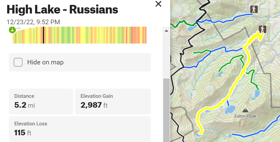
- High Lake from Little Duck Lake = 5.2 miles
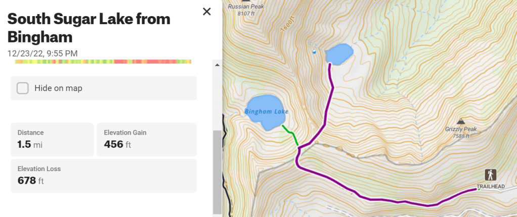
- South Sugar Lake from Bingham Trail pass = 1.5 miles
Big Blue Loop = 8.5 miles

High Lake from Duck Lake Trailhead via Little Duck Lake = 5.2 miles w/XC
South Sugar Lake from Bingham Lake Trailhead = 1.5 miles w/ XC
Russian Lake = 4 miles