Lost Coast Headlands

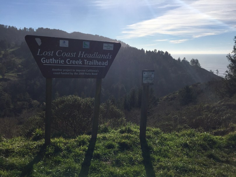
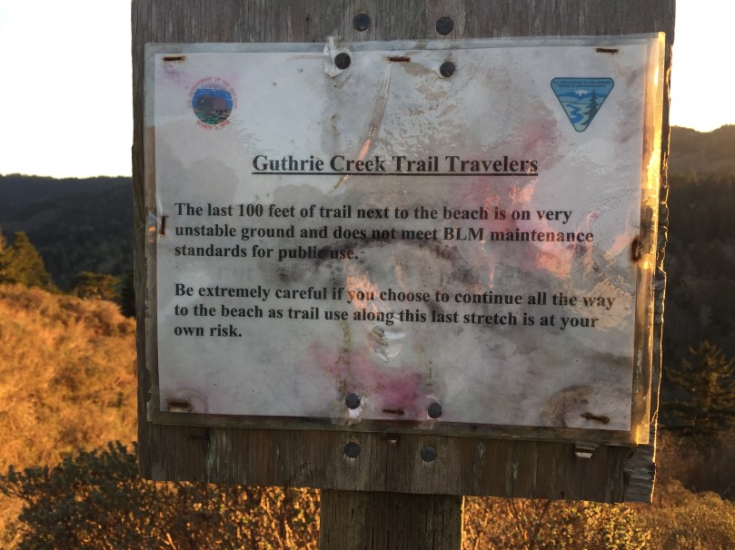
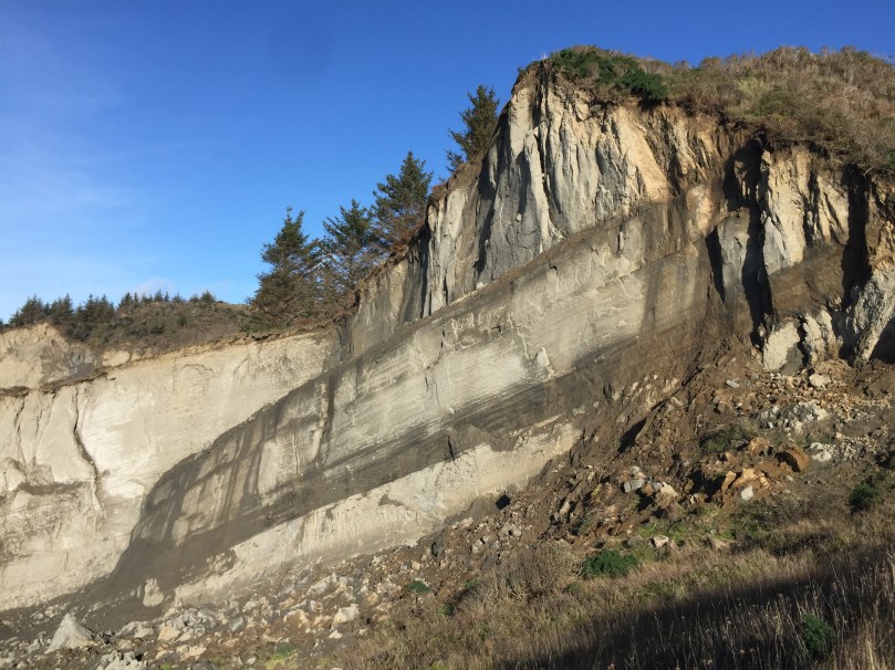
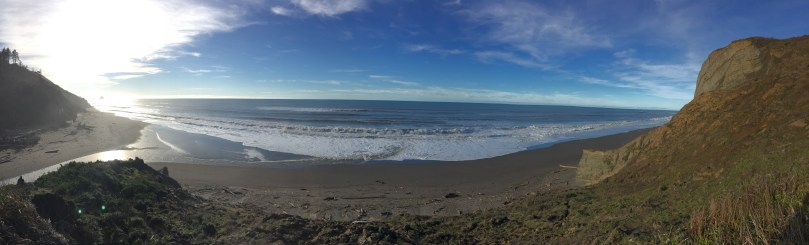
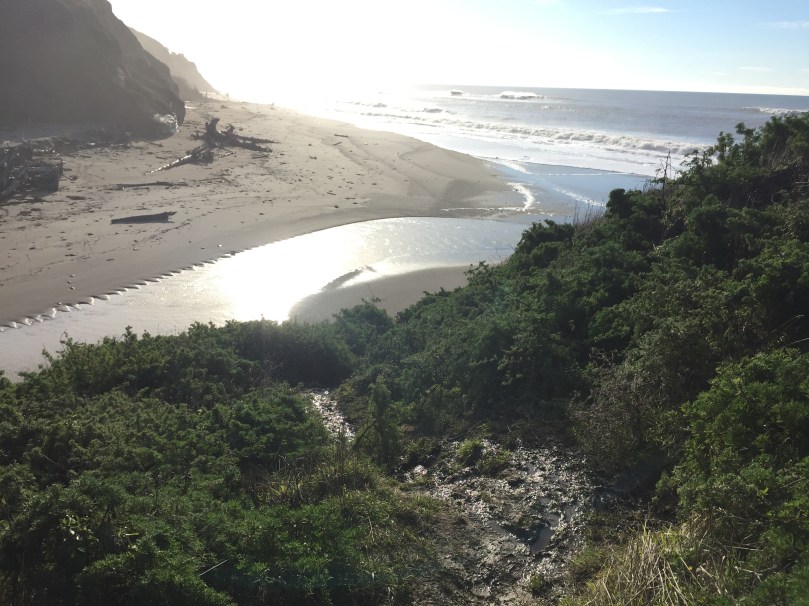
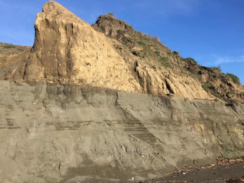
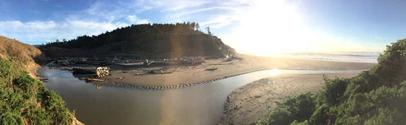
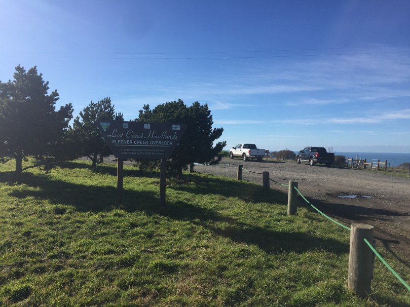
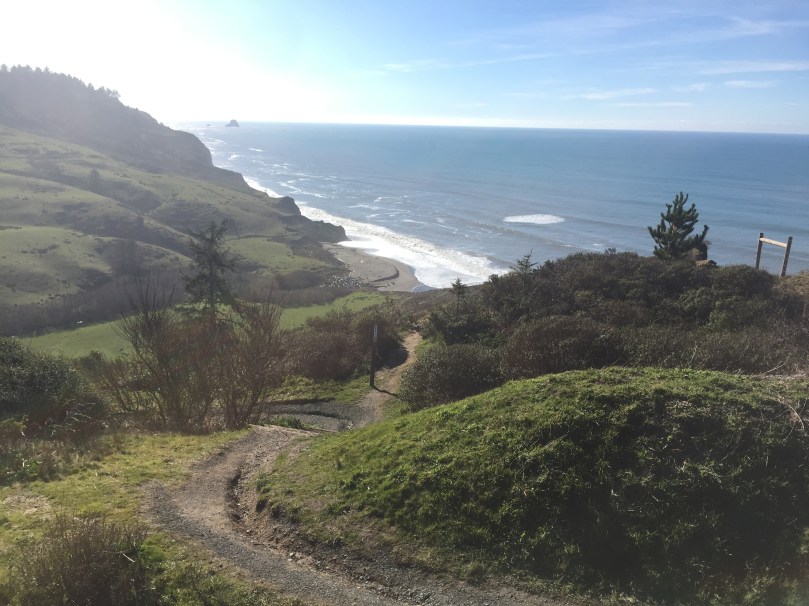
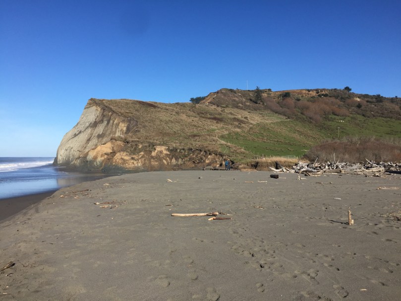
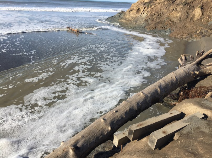
Lost Coast Headlands consists of two moderate trails to secluded, rugged beaches, at the end of the road to Centerville Beach in Ferndale. The first is Fleener Creek Trail, 0.5 miles downhill to the beach. Guthrie Creek Trail is 1.0 miles downhill to the beach. Both can be difficult and possibly unsafe in muddy conditions, especially Guthrie Creek Trail that has a steep muddy patch right before the beach that some people were turning back from. Fleener Creek Trail has a large driftwood pile that must be carefully crossed, or short wood stairs leading to a creek crossing, after a steep muddy descent to the beach that a sign at the trailhead warns about. If you have bad knees or ankles, you might not want to try these trails in winter, and walking poles are recommended.

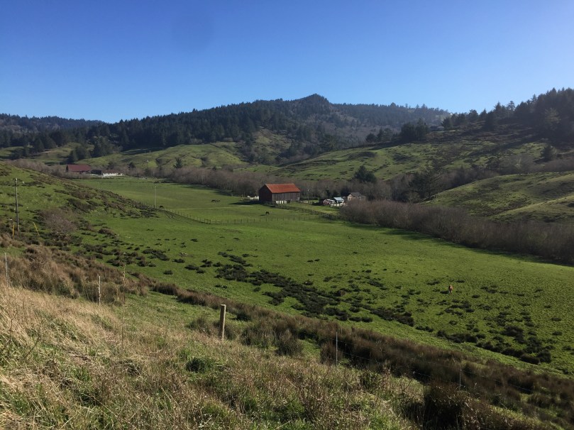
FLEENER CREEK TRAIL – PHOTOS

img_4579

img_4592

img_4616

img_4624

img_4629

img_4638

img_4670

GUTHRIE CREEK TRAIL – PHOTOS


img_4674

img_4906


IMG_4681.JPG

img_4690img_4741img_4754img_4773img_4777img_4862

English Peak – Marble Mountain Wilderness

  • Recommended Route: North Fork Trail from Mulebridge Campground, up the North Fork of the Salmon River.
    • Trail is recommended for mid to late summer due to high flows at creek crossings.
    • The Garden Gulch and Little North Fork Trails are not recommended.
  • Season: June – October
  • Moderate to Difficult Trail
  • Camping: Idlewild or Mulebridge Campgrounds on North Fork Salmon River

From the Mulebridge Trailhead going up the North Fork Salmon River:

  • 13 miles to Hancock Lake
  • @ 6 miles in, Right Hand Fork trail
  • @ 8.5 miles in, Lake of the Island Trail
    • 2 miles OW to Lake of the Island, river crossing, 4,200 feet elevation
    • Lake of The Island: 13 acres, 25 feet deep, 5,600 feet elevation, brook and rainbow trout
  • @ 10.5 miles, Abbott Lake Trail, 2 river crossings past Lake of the Island Trail
    • 1 mile OW climb to lake, river crossing, 4,800 feet elevation
    • Abbott Lake: 8 acres, 20 feet deep, 5,700 feet elevation, brook trout
  • @ 10.5 miles Big Meadows/Big Gulch Trail to Wild Lake, Lake Ethel, Lake Katherine, Horse Range Lake, Wooley Creek
  • @ 13.5 miles – Horse Range Lake (+3 steep miles from Abbott Cabin)
  • @ 14.5 miles – Wild Lake (+4 steep miles)
  • Exiting Wooley Creek Trail #5832 = 19 miles from junction with Big Meadows Trail from Wild Lake, to the Wooley Creek Trailhead
  • Exiting Marble Rim
    • Big Elk Lake is 7.3 miles from Lover’s Camp Trailhead
  • Exiting Garden Gulch or Little North Fork Trail – not recommended


Duck Lakes – Russian Wilderness

  • 4 miles to Big Duck Lake, 0.5 miles further to Little Duck Lake
  • 2+ Day Trip

Details:

  • Best season = June to October
  • Moderately strenuous hike
  • Great views to Mount Shasta, Salmon Mountains and Scott Valley
  • Duck Lake Special Interest Area/Botanical Area
    • Known as the Miracle Mile, 17 conifer species are present in the drainage
    • Relic species: Foxtail pine, Englemann spruce, subalpine and Pacific silver fir
  • Approximately 4 hour drive from Eureka, CA on Highway 299 to 3 near Callahan:
    • From Highway 3 between Callahan and Etna, CA
    • Turn west on French Creek Road for 6.7 miles
    • Right on 40N22 for 1 mile
    • Right on 41N14 for 1.3 miles to parking area
  • Hiking to Duck Lakes from Duck Lake Trailhead @ 4800 feet elevation:
    • 4 mile moderate hike from Duck Lake Trailhead to Big Duck Lake
      • Big Duck Lake = 26 acres @ 27 feet deep @ 6400 feet elevation
      • Eastern brook trout and rainbow trout
      • Largest lake in the Russian Wilderness
      •  0.5 mile difficult hike with 700 foot elevation gain to Little Duck LakeLittle Duck Lake = 5 acres @ 18 feet deep @ 6700 feet elevation
        • Eastern brook trout
  • Hiking to Horseshoe Lake:
    • 4 mile moderate hike from Duck Lake Trailhead to Horseshoe Lake
    • 1.5  mile moderate hike from Duck/Eaton Lakes Trail intersection
      • Horseshoe Lake = 6.1 acres @ 21 feet deep @ 6400 feet elevation
      • Eastern brook trout and rainbow trout
  • Hiking to Lipstick Lake:
    • 4 mile difficult hike from Duck Lake Trailhead to Horseshoe Lake
    • 3 mile moderate hike from Music Creek Trailhead to Horseshoe Lake
      • Horseshoe Lake = 1.25 acres @ 9 feet deep @ 6350 feet elevation
      • Eastern brook trout
  • Hiking to Eaton Lakes:
    • 4.5 mile difficult hike from Duck Lake Trailhead to Eaton Lake
    • Approximately 1 mile difficult hike from Duck/Eaton Lakes Trail intersection
      • Eaton Lake = 11 acres @ 27 feet deep @ 6600 feet elevation
      • Trail is steep and hard to follow, not recommended for stock
      • Private property
      • Rainbow trout

Links:

  • Driving Directions – About 4 hours from Eureka, CA via Highway 299 to 3
  • Alternative Scenic Route: Salmon River Road

Botanical Areas

  1. Bear Basin Butte – Six Rivers National Forest
  2. Bear Peak – Siskiyou Wilderness
  3. Broken Rib Botanical Area – Six Rivers National Forest
  4. China Mountain – Klamath National Forest
  5. Cook and Green Botanical Area – Klamath National Forest
  6. Cory Peak – Klamath National Forest
  7. Darlingtonia Trail – Smith River National Recreation Area
  8. Elk Hole – Klamath National Forest
  9. Gray Pine Botanical Area – Klamath National Forest
  10. Horse Creek – Klamath National Forest
  11. Indian Creek Brewer Spruce – Klamath National Forest
  12. Little Shasta Meadow – Klamath National Forest
  13. Mount Ashland Siskiyou Peak Botanical Area – Klamath National Forest (Oregon)
  14. Observation Peak Botanical Area – Klamath National Forest (Oregon)
  15. Poker Flat Botanical Area – Klamath National Forest/Siskiyou Wilderness
  16. Preston Peak – Siskiyou Wildenerness
  17. Red Mountain Botanical Area – Klamath National Forest (Oregon)
  18. Rhododendron Patch Botanical Area – Klamath National Forest
  19. Rock Fence Creek – Klamath National Forest
  20. Scott Mountain – Klamath National Forest
  21. Seiad Baker Cypress  – Klamath National Forest
  22. Sutcliff Creek – Rogue River-Siskiyou National Forest
  23. White Mountain – Klamath National Forest


Lost Coast Trail

NORTHERN LOST COAST TRAIL

  • 24.8 miles along the Pacific Ocean north of Shelter Cove
  • Mattole Beach to Black Sand Beach in Shelter Cover
  • 3-4 days each way
  • Usually hiked north to south for wind reasons

SOUTHERN LOST COAST TRAIL

  • 22.1 miles along the Pacific Ocean south of Shelter Cove
  • Needle Rock Beach  to Usal Beach
  • 3-4 days each way
  • Usually hiked north to south for wind reasons


Major Trails

Major Trails and National Recreation Trails (NRTs) in Northwestern California:

  1. Bigfoot Trail – Northern California
  2. Boundary Trail – Kangaroo NRT – Klamath National Forest
  3. Bumpas Hell NRT – Lassen Volcanic National Park
  4. Clear Creek NRT – Siskiyou Wilderness
  5. Coastal Trail NRT – Redwood National Park
  6. Heart Lake NRT – Lassen National Forest
  7. High Grade NRT – Modoc National Forest
  8. Horse Ridge NRT – Six Rivers National Forest
  9. Ides Cove Loop NRT – Yolla Bolly Middle Eel Wilderness
  10. Kelsey NRT (Section 1) – Siskiyou Wilderness
  11. Kelsey NRT (Section 2) – Siskiyou Wilderness
  12. King Range NRT – King Range National Conservation Area
  13. McGowan NRT – Lassen National Forest
  14. Middle Fork Applegate NRT – Siskiyou National Forest
  15. Lassen Peak NRT – Lassen Volcanic National Park
  16. Lost Coast NRT – King Range National Conservation Area
  17. Pacific Crest NRT – Northern California
  18. Sacramento River Trail – City of Redding
  19. Salmon Summit NRT – Six Rivers National Forest
  20. Sisson-Callahan NRT – Shasta Trinity National Forest
  21. South Fork NRT – Shasta Trinity National Forest
  22. South Kelsey NRT – Siskiyou Wilderness
  23. Spencer Meadow NRT – Lassen National Forest
  24. Travelers Home NRT – Mendocino National Forest