- Avenue of the Giants – Humboldt Redwoods State Park
- Bigfoot Scenic Byway (Highway 96) – Six Rivers National Forest
- California Backcountry Discovery Trail – Humboldt, Mendocino and Lake Counties
- Howland Hill – Jedediah Smith Redwoods State Park
- Lost Coast – King Range Conservation Area
- Modoc Volcanic Scenic Byway – Modoc National Forest
- Newton B. Drury (Redwood Scenic) Parkway – Prairie Creek Redwoods State Park
- State of Jefferson Scenic Byway – Klamath National Forest
- Smith River Scenic Byway (Highway 199)- Smith River National Recreation Area
- Trinity Heritage Scenic Byway (Highway 3) – Shasta-Trinity National Forest
- Trinity Scenic Byway (Highway 299) – Shasta-Trinity National Forest
- Yurok Scenic Byway (Bald Hills Road) – Redwood National Park
Category: Driving/Riding Activities
Shasta-Trinity National Forest
Lost Coast
The Lost Coast is a rugged coastal wilderness that feels like an escape to another world. As the longest undeveloped coastal region in the contiguous US, you can hike along the ocean for days.
- BLM King Range Conservation Area
- 68,000 acres
- King Range Wilderness
- 42,694 acres
- King Range Trail Map
- King Range Road Map
- Lost Coast Trails Blog
- Lost Coast Scenic Drive
- Punta Gorda Lighthouse
- Lost Coast Headlands
- Paradise Royale Mountain Biking Trail
- Surf the Lost Coast – National Geographic

Yolla Bolly – Middle Eel Wilderness
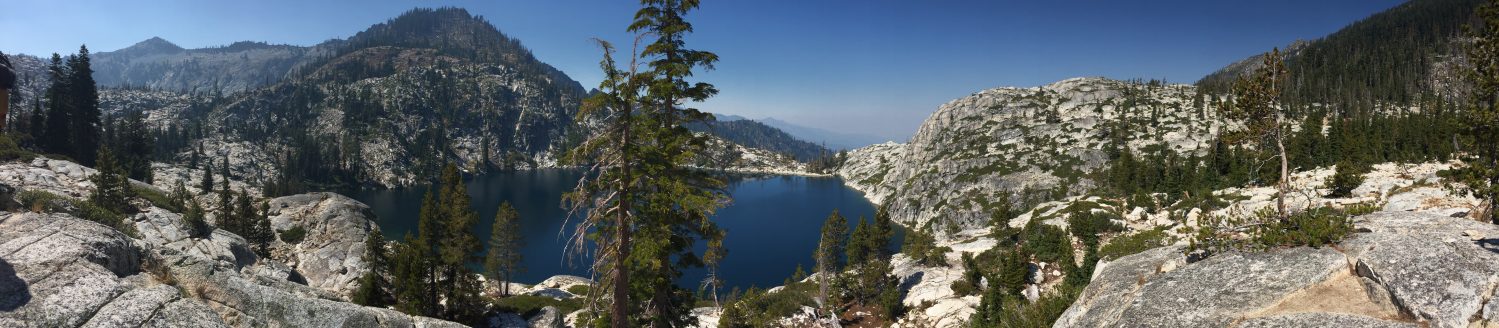
Russian Wilderness
Nor-Cal Adventures Blog Pages:
- Russian Wilderness Lakes
- Russian Wilderness Map
- Salmon River
- Klamath National Forest
- Pacific Crest Trail
Helpful links to other pages:
Hiking Trails:
- Big Blue Lake Loop = 8.5 miles
- Paynes Lake
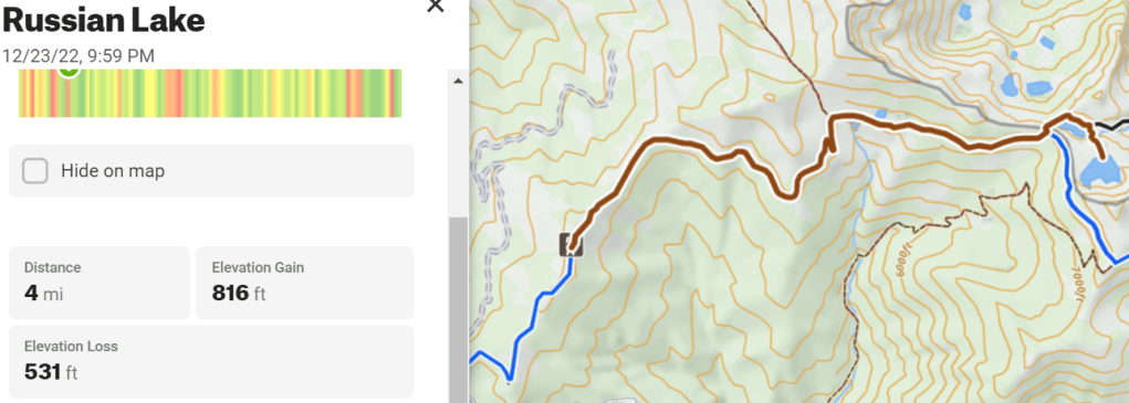
- Russian Lake = 4 miles
- Bingham Lake
- Smith Lake
- Statue Lake
- Duck Lakes
- Sugar and High Lakes
- Week-long Highlights Trip
- Pacific Crest Trail
Hiking Trails:
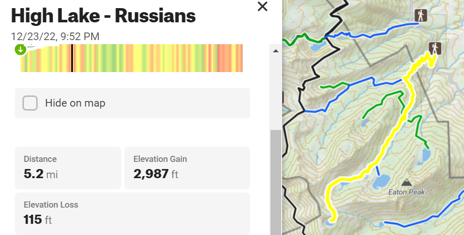
- High Lake from Little Duck Lake = 5.2 miles
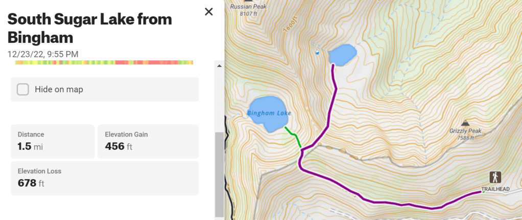
- South Sugar Lake from Bingham Trail pass = 1.5 miles
Big Blue Loop = 8.5 miles

High Lake from Duck Lake Trailhead via Little Duck Lake = 5.2 miles w/XC
South Sugar Lake from Bingham Lake Trailhead = 1.5 miles w/ XC
Russian Lake = 4 miles
Marble Mountain Wilderness
Hiking Trails:
- Marble Rim
- English Peak
- Ukonom
Isolated long distance treks:
- Wooley Creek
- Kidder Creek to Shelly Fork
- Kidder Creek to Portuguese
- Pacific Crest Trail
Smith River National Recreation Area
Backcountry Discovery Trail
- ~200 miles of 4-wheel driving in the Coast Mountains of Northern California
- WestCounty Explorer’s Club article
- Six Rivers National Forest
- Mendocino National Forest
Kidder Creek to Shelly Fork
- 60 miles of isolated trekking exploring most of the Marble Mountains
- Kidder Creek Trail #5545
- Pacific Crest Trail to Four Corners near Marble Rim
- Kelsey National Recreation Trail to Cuddihy Lakes
- Bridge Creek Trail #5816 south to Wooley Creek Trail #5832 heading northeast
- Big Meadows Trail #5411 south to North Fork Trail #5405 east
- Right Hand Fork Trail #5401 east to Shelly Fork Trail #5527
- End at Shelley Fork Trailhead
