Highway 96 at Seaid Valley to Oregon border
Author: darabylah
Sierra Highways and Passes
- Highway 80
- Sacramento to Truckee/Reno
- Tahoe National Forest
- Highway 50
- Echo Summit 7379ft
- Sacramento to Lake Tahoe
- Eldorado National Forest
- Highway 108
- Sonora Pass 9609ft
- Modesto/Pinecrest Lake
- Stanislaus National Forest
- Highway 49
- Highway 36
- Red Bluff to Chester/Lake Almanor
- Highway 70
- Oroville to Portola
- Highway 120
- Tioga Pass 9944ft
- Modesto to Yosemite to Mono Lake
- Yosemite National Park
- Highway 4
- Ebbetts Pass 8756ft
- Stockton to Markleeville
- Stanislaus National Forest
- Highway 88
- Yuba Pass 6800ft
- Stockton to Markleeville
- Caples Lake
- Stanislaus National Forest
- Highway 89
- Highway 178
- Bakersfield to Ridgecrest
- Sequoia National Forest
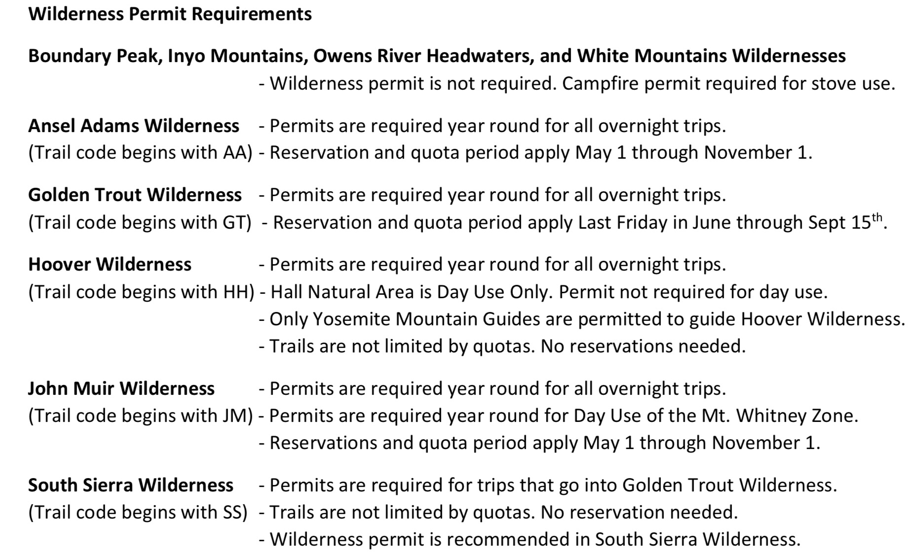
Sierra Permits
- https://www.fs.usda.gov/Internet/FSE_DOCUMENTS/stelprdb5143453.pdf
- Yosemite National Park
- Permit required year round for overnight stay in backcountry
- https://www.nps.gov/yose/planyourvisit/wildpermits.htm
- Day hiking doesn’t require permit except Half Dome
- https://www.nps.gov/yose/planyourvisit/hdwildpermits.htm
- First come first served permits for backcountry and Half Dome exist
- https://yosemite.org/yosemite-wilderness-permit-request-form/
- John Muir Trail has special backcountry permit system
- John Muir Trail
- Permit required to start John Muir Trail in Yosemite National Park
- Exit quota southbound at Donahue Pass
- https://web.archive.org/web/20190611123959/https://www.nps.gov/yose/planyourvisit/upload/wildernesstrailheads.pdf
- First Come First Served permits exist from nearest priority permit issuing station, starting at 11am the day of the hike
- Five permit trailhead entries for John Muir Trail
- Lyell Canyon
- Sunrise Lakes
- Happy Isles thru Little Yosemite Valley
- Happy Isles thru Merced Lake
- Glacier Point thru Little Yosemite Valley
- Inyo National Forest
- Quotas
- Backcountry permits required overnight, Permits online
- https://www.recreation.gov/permits/233262
- Ansel Adam’s Wilderness
- John Muir Trail
- Sierra National Forest
- No permit for day hiking
- 40% of permits are first come first served
- Paper Permit application for backcountry overnight trips
- Apps accepted in January for May-Oct, no closer than 3 weeks ahead of trip
- https://web.archive.org/web/20201105072751/https://www.fs.usda.gov/Internet/FSE_DOCUMENTS/fsbdev7_017679.pdf
- https://web.archive.org/web/20200509005511/https://www.fs.usda.gov/detail/sierra/passes-permits/?cid=fsbdev7_018115
- Golden Trout Wilderness
- Paper Application for backcountry permit required
- https://www.fs.usda.gov/detail/sequoia/passes-permits/recreation/?cid=fsbdev3_059517
- Whitney Zone
- Sequoia National Forest
- No permits except Golden Trout Wilderness
- Humboldt-Toiyabe National Forest
- Only Hoover Wilderness requires backcountry permit
- https://web.archive.org/web/20170710183528/https://www.fs.usda.gov/Internet/FSE_DOCUMENTS/stelprdb5253870.pdf
- Stanislaus National Forest
- No quotas
- Permit required for overnight trips in Emigrant, Carson-Iceberg Wilderness and Mokelumne Wilderness from April 1- Nov 30
- https://web.archive.org/web/20201016223922/https://www.fs.usda.gov/attmain/stanislaus/specialplaces
- https://web.archive.org/web/20200818012214/https://www.fs.usda.gov/detailfull/stanislaus/passes-permits/recreation/?cid=stelprdb5361242&width=full#permits
- John Muir Trail
- Pacific Crest Trail
- High Sierra Trail
- Desolation Wilderness
Gateways to the Sierras
Northwest
- Folsom Lake – 2 hours, Verizon
- Lake Oroville – 2.5 hours, Verizon
- Rollins Reservoir – 2.5 hours, Verizon
- Union Valley Reservoir – 3 hours, Verizon
- Ice House Reservoir – 3 hours, Verizon
Central West
- Yosemite Valley – 3.5 hours, Verizon
- Camanche Reservoir – 2 hours, Verizon
- New Hogan Lake – 2 hours, Verizon
- Salt Spring Valley Reservoir – 2 hours, Verizon
- New Melones Lake – 2.5 hours, Verizon
- Tulloch Reservoir – 2.5 hours, Verizon
- Pinecrest Lake – 3 hours, Verizon
- Beardsley Lake – 3.5 hours, No Verizon
- Don Pedro Reservoir – 2.5 hours, Spotty Verizon
- Lake McClure – 2.5 hours, Very Spotty Verizon
- Bass Lake – 3.5 hours, Verizon
- Mammoth Pool – 5 hours, No Verizon
- Mono Hot Springs 5 hours, No Verizon
- Vermillion Valley/Lake Thomas Edison – 6 hours, No Verizon
Southwest
- Pine Flat Reservoir – 3.5 hours, Very Spotty Verizon
- Grant Grove Village – 4 hours, Verizon
- Lake Kaweah – 4 hours, Verizon
- Millerton Lake – 3 hours, Verizon
- Shaver Lake – 4 hours, Verizon
- Huntington Lake – 4.5 hours, Verizon
- Courtright Reservoir – 5 hours, No Verizon
- Wishon Reservoir – 4.5 hours, Very Spotty Verizon
- Florence Lake – 6 hours, No Verizon
- Lake Success – 4.5 hours, Spotty Verizon
- California Hot Springs – 5 hours, No Verizon
- Isabella Lake – 5.5 hours, Verizon
- Bakersfield – 4.5 hours, Verizon
Northeast
- Bridgeport Reservoir – 4.5 hours, Verizon
- Mono Village/Twin Lakes – 5 hours, No Verizon
- Topaz Lake – 4 hours, Verizon
- Grover Hot Springs – 4 hours, No Verizon
- Lake Tahoe – 3.5 hours, Verizon
Central East
- Mono Lake – 5.5 hours
- Silver Lake – 6 hours
- June Lake – 6 hours
- Mammoth Lakes – 6 hours
- Convict Lake – 6 hours
- Devils Postpile – 6 hours, Very Spotty or No Verizon
- Lake Crowley – 6.5 hours, Verizon
- Bishop – 6.5 hours, Verizon
- Big Pine – 7 hours, Verizon
Southeast
- Tinemaha Reservoir – 7 hours, Verizon
- Independence – 7.5 hours, Verizon
- Owens Lake – 7.5 hours, Verizon
- Ridgecrest – 6.5 hours, Verizon
- Mojave -6 hours, Verizon
Carson-Iceberg Wilderness
Stanislaus National Forest
Primary access:
- Lake Alpine – Stanislaus National Forest
- Spicer Meadow Reservoir – Stanislaus National Forest
- Highland Lakes – Stanislaus National Forest
- Sand Flat – Stanislaus National Forest
- Lower Blue Lake
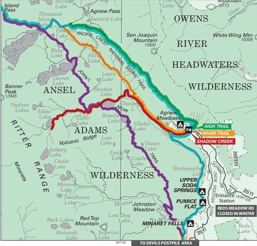
Ansel Adams Wilderness
Within Sierra National Forest
Borders John Muir Wilderness in Humboldt-Toiyabe National Forest (southeast), Inyo National Forest (north), and Yosemite Wilderness (northwest).
Main access from Reds Meadows (east), Mammoth Lakes (east), June Lake (northeast), Tuolumne Meadows (northwest), and Lake Thomas Edison (southeast).
Permits become available at 7am PST six months before the date of the permit.
Permits on Recreation.gov: https://www.recreation.gov/permits/233262
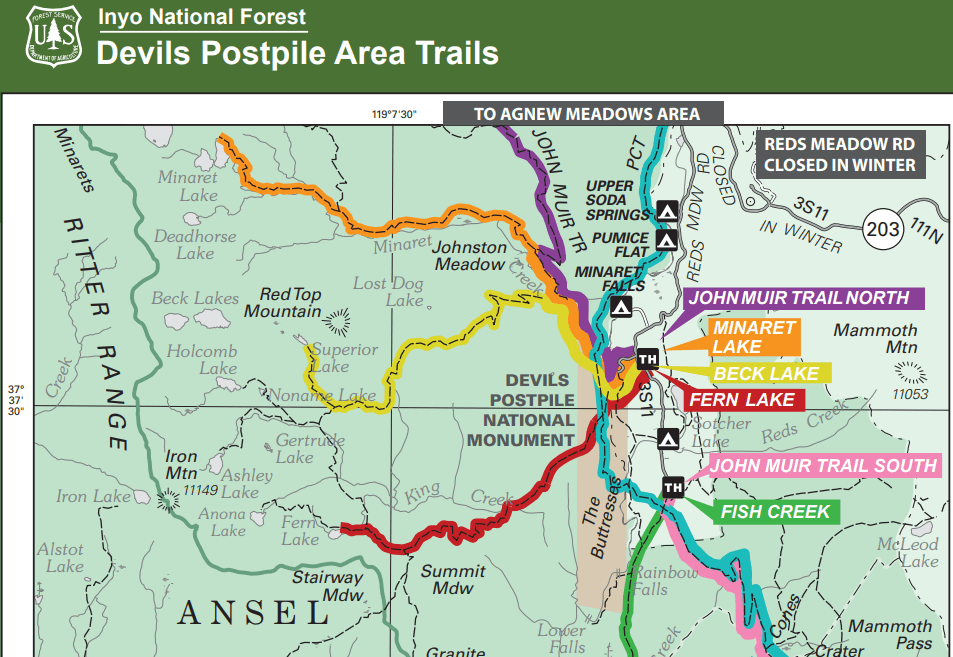
Devil’s Postpile Area Trails: https://www.fs.usda.gov/Internet/FSE_DOCUMENTS/stelprdb5337628.pdf
Agnew Meadows Area Trails: https://www.fs.usda.gov/Internet/FSE_DOCUMENTS/stelprdb5337626.pdf
Entrances:
- Southern Entrances:
- Lake Thomas Edison
- Mono Hot Springs
- Western Entrances:
- Clover Meadow
- Yosemite Wilderness
- Northern Entrances:
- Tuolumne Meadows
- Eastern Entrances:
- Silver Lake
- Agnew Meadows
- Mammoth Lakes
- Reds Meadows
Highlights:
- California Hiking and riding trail
- Pacific crest trail
- Thousand Island Lake
Planned Adventure Loops:
Start at a trailhead near Agnew Meadows
- High Trail (AA09)
- River Trail (AA08)
- John Muir Trail North (AA10)
- Shadow Creek (AA07)
- Minaret Lake (AA11)
- Beck Lake (AA12)
- Fern Lake (AA13)
- Fish Creek (AA14)
- Rush Creek (AA05)
Rush Creek Option
- Agnew Lake = 2.2 miles
- Agnew Pass via Spooky Meadows Trail = 4 miles
- Agnew Pass via Gem Lake = 7 miles
- Gem Lake = 4.6 miles (this option adds 3 miles to the trip, but may be an easier way to reach Agnew Pass)
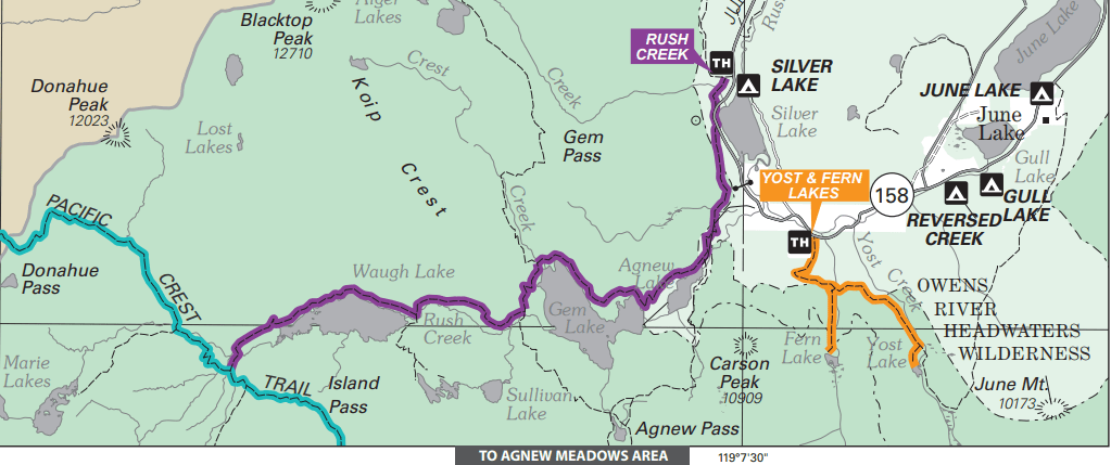
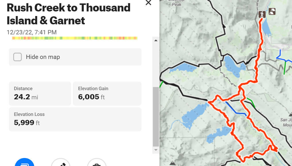
- Quickest Loop: Rush Creek Trailhead to Thousand Island Lake, Garnet Lake and back through Agnew Pass = 17.4 miles
- Rush Creek to Agnew Meadows via Thousand Island and Garnet Lakes = 17.6 miles
- Rush Creek Trailhead to Thousand Island Lake, Garnet Lake and back through Agnew Pass = 24 miles
Eastern Sierra Transit
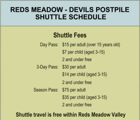
- Red’s Meadow Shuttle starts 6/17: https://www.estransit.com/routes-schedule/seasonal/reds-meadow-shuttle/
- Red’s Meadow Shuttle: https://www.estransit.com/wp-content/uploads/2022/06/2022RedsShuttle-Map-2.pdf
- Shuttle within Red’s Meadow Valley is free
- The shuttle runs daily, on the following frequencies:
- 7:30 am – 9:00 am – every 45 minutes
- 9:00 am – 10:00 am – every 30 minutes
- 10:00 am – 4:00 pm – every 20 minutes
- 4:45 pm – 6:15 pm – every 45 minutes
- The last bus into the Valley departs Mammoth Adventure Center at 6:15 pm.
- The last bus out of the Valley departs Reds Meadow Resort at 7:00 pm.
- The last day for the 2022 Shuttle Season is expected to be September 5, 2022
- 2022RedsShuttle Map
Other Shuttles
https://climber.org/data/shuttles.html
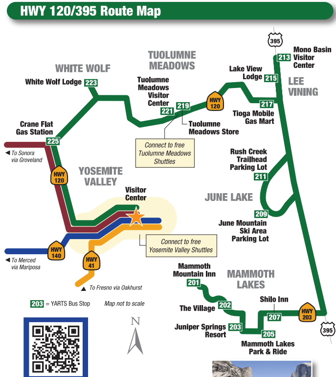
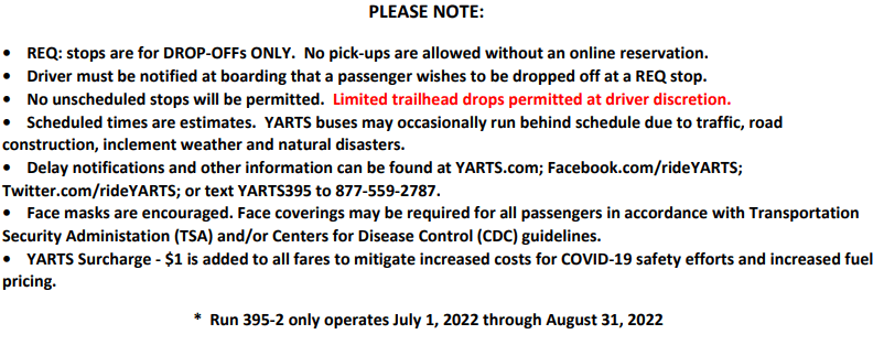
YARTS – Yosemite Area Rapid Transit
Rush Creek Trailhead requires a reservation with YARTS for pickup, none required for Drop-off just notify the Driver.
Need to call, the online reservation doesn’t seem to work
YARTS & EST meet at Mammoth Mountain Inn
Emigrant Wilderness
Stanislaus National Forest
Primary access is from Pinecrest Lake
Borders Hoover Wilderness in Humboldt-Toiyabe National Forest (East), and Yosemite Wilderness (south)
Pacific Crest Trail skirts along the eastern edge of Emigrant Wilderness = ? Miles ? To Sonora Pass
- Western Entrances
- Pinecrest Lake
- Northern Entrances
- Eagle Meadow
- Kennedy Meadows
- Southern Entrances
- Cherry Lake – Shingle Springs Trailhead
- Eastern Entrances
- PCT in Hoover Wilderness
- PCT in Yosemite Wilderness
- Highlights:
- Emigrant Lake
- Basecamp Lakes:
- Pinecrest Lake – Stanislaus National Forest
- Cherry Lake – Stanislaus National Forest
- Lake Eleanor – Yosemite Wilderness
- Hetch Hetchy – Yosemite Wilderness
- Leavitt Lake – Bridgeport Winter Recreation Area
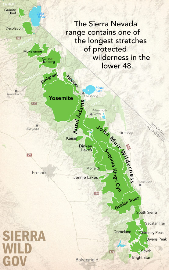
Sierra Nevada Wilderness
Wilderness Areas:
- Driving from San Francisco
- Northern Sierra Nevada:
- Granite Chief = 3.5 hours
- Desolation = 3.5 hours
- Mokelumne = 4 hours
- Carson-Iceberg = 3.5 hours
- Emigrant = 3.5 hours
- Hoover = 5 hours
- Yosemite = 4 hours
- Ansel Adams
- Central Sierra Nevada:
- Kaiser = 5 hours
- Dinkey Lakes = 5 hours
- John Muir Wilderness = 6.5 hours
- Sequoia Kings Canyon = 4.5 hours
- Monarch = 5 hours
- Jennie Lakes = 5.5 hours
- Southern Sierra Nevada:
- Golden Trout
- South Sierra
- Sacatar Trail – BLM, High desert
- Domeland – BLM, High desert
- Chimney Peak – BLM, High desert
- Owens Peak – BLM, High desert
- Kiavah = 6.5 hours to PCT south of Walker Pass – BLM, High desert
- Bright Star – BLM, High desert
Sierra Nevada Airports
- Sacramento (SMF)
- $160 RT @1 hr from SFO
- United (SFO)
- Sacramento Intl Airport
- Driving = 2.5 hours each way from SF
- Fresno (FAT)
- $150 RT @1 hr from SFO
- United (SFO), American
- Fresno Yosemite Intl Airport
- Driving = 3 hours each way from SF
- Bakersfield (BFL)
- $150 RT @1.25 hrs from SFO
- United (SFO), American
- Meadows Field Airport
- Driving = 4 hours each way from SF
- Reno (RNO)
- $100 RT @1 hr 10 min from SFO
- United (SFO), American, Southwest (OAK)
- Reno-Tahoe Intl Airport
- Driving = 4 hours each way from SF
- Redding (RDD)
- $300 RT @
- No flights
- Stockton (SCK)
- Mammoth Lakes (MMH)
Best trail running areas for long distance hiking
- Russian Wilderness PCT
- Trinity Alps PCT
- Haypress Trail – Marble Mountain Wilderness
- Marble Mountain PCT
- Mt Eddy PCT
- South Kelsey Trail – Siskiyou Wilderness
- English Peak – Marble Mountain Wilderness
- Swift Creek Trail – Trinity Alps Wilderness
- Stuart Fork Trail – Trinity Alps Wilderness
